![]()
01782 944945
Principal: Steve Butler MRICS Chartered Surveyor
Steve Butler Chartered Surveyors Marcus House, Park Hall Business Village, Park Hall Road, Stoke on Trent, ST3 5XAOpen 8.30am to 6.30pm
BOUNDARY DISPUTE LAND REGISTRY AND RIGHT OF WAY SURVEYS STOKE ON TRENT, NEWCASTLE UNDER LYME, CREWE, STONE, CHEADLE, UTTOXETER, LEEK
Property owners are often neglectful of their boundaries until it is to late. Once the neighbour has chopped down that tree that you thought was yours it is extremely hard to put it back up again.
However if you have suitable tile deeds then it is possible to attempt to resolve many disputes. Measurements can be taken and pegs knocked in to enable a boundary line to be established. Alternatively documents, photographs and drawings can be prepared to support (or disprove) a county court action for compensation and or to get a hedge or fence re-erected in its correct location.
Unfortunately the help we can give is only usually only as good as your title deeds. The current land registry title plans are not very accurate and only enable boundaries to be estimated to the nearest half a metre. This is due to the small scale of the plans on which the boundaries of a property are drawn. It is thus well worth saving copies of old tile deeds with measurements or drawings. When buying a property it is wise to agree the ownership of any unclear boundaries with your prospective neighbours.
In the absecne of title deeds it may be possible to draw conclusions about the line of a boundary or right of way from features on the ground old photographs or possibly OS sheets. Steve Butler has access to a range of historic OS sheest some dating back to before 1900. Care should however be taken before relying on OS sheets. The purpose of the maps is not to identify legal boundaries but features on the ground that may be legal boundaries but may also just be features or near to leglal boundaries. The OS plans are also prepared at a scale of 1:1250 or 1:2500 where 1mm on the map is 1.25m or 2.5m on the ground. The maps are thus difficult tif not impossible to scale off. The maps whilst usualy very accurate can contain errors and were presumably prepared with the care appropriate to a map on such a large scale.
My land registy account also enables me to access the Title Register and Title Plans for nearby properties and more importantly I can often get copies of the original conveyance documents for nearby properties.
Stoke on Trent right of way and boundary dispute report


The claimant wanted to argue she had a right of way with a vehicle from a public car park through a splay that was persistently blocked by the land owner first with a car that was subsequently burnt out and then with bollards. Unfortunately, the judge found she had been using the splay for just short of the twenty years required for a right of way by prescription, she did not have a right of way by conveyance and that she had not acquired the right of way under Section 62 of the LPA 1925. It was found under cross examination that access to the splay had been blocked by a wall which was demolished less than twenty years ago and that an alternative access had existed at the time which had subsequently become blocked and then re-opened.
BOUNDARY AND RIGHT OF WAY SURVEYORS REPORT STOKE ON TRENT
Steve Butler has extensive experience of writing reports in to such matters including preparing CPR35 complaint reports for court and acting as an expert witness. Steve Butler membership of the Chartered Institution of Legal Executives is a particular advantage when drafting report for the Court and understanding pre-trial procedure. Steve Butler have a very accurate Total Station laser measure which can produce drawings in three dimensions and is particuarly useful for measuring the track and meanders of boundaries in relation to other objects. Plans can often by laid over original conveyance documents using CAD software for comparison purposes.
Independent surveyors report on a boundary dispute and nuisance neighbour for county court
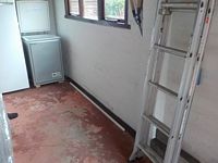
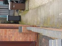
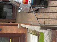
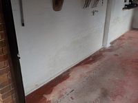
This boundary survey report was in respect of a garage. A neighbour had constructed a raised hardstanding using the garage as a retaining wall. This had allowed water to run of the hardstanding into the garage staining the walls and causing pools of water on the floor. Our boundary surveyors were able to prepare a report suggesting that the boudary was some six inches away from the garage.
![]()